Spherical Earth

Medieval artistic representation of a spherical Earth - with compartments representing
earth,
air, and
water (c. 1400).
The concept of a
spherical Earth dates back to ancient
Greek philosophy from around the 6th century BC,
[1] but remained a matter of philosophical speculation until the 3rd century BC when
Hellenistic astronomy established the spherical
shape of the earth as a physical given. The Hellenistic paradigm was gradually adopted throughout the
Old World during Late Antiquity and the Middle Ages.
[2][3][4][5] A practical demonstration of Earth's sphericity was achieved by
Ferdinand Magellan and
Juan Sebastian Elcano's expedition's
circumnavigation (1519−1521).
[6]
The concept of a spherical Earth displaced earlier beliefs in a
flat Earth: In early
Mesopotamian mythology, the world was portrayed as a flat disk floating in the ocean and surrounded by a spherical sky,
[7] and this forms the premise for
early world maps like those of
Anaximander and
Hecataeus of Miletus. Other speculations on the shape of Earth include a seven-layered
ziggurat or
cosmic mountain, alluded to in the
Avesta and ancient
Persian writings (see
seven climes), or a wheel, bowl, or four-cornered plane alluded to in the
Rigveda.
[8]
The realization that the
figure of the Earth is more accurately described as an
ellipsoid dates to the 18th century (
Maupertuis). In the early 19th century, the flattening of the earth ellipsoid was determined to be of the order of 1/300 (
Delambre,
Everest). The modern value as determined by the
US DoD World Geodetic System since the 1960s is close to 1/298.25.
[9]
History
Antiquity
Classical Greece
Though the earliest evidence of a spherical Earth comes from ancient
Greek sources, there is no account of how the sphericity of the Earth
was discovered.
[10]
A plausible explanation is that it was "the experience of travellers
that suggested such an explanation for the variation in the observable
altitude and the change in the area of circumpolar stars, a change that was quite drastic between
Greek settlements" around the eastern
Mediterranean Sea, particularly those between the
Nile Delta and the
Crimea.
[11]
According to
Diogenes Laertius, "[
Pythagoras ] was the first [Greek] who called the earth round; though
Theophrastus attributes this to
Parmenides, and
Zeno to
Hesiod."
- Pythagoras
Early Greek philosophers alluded to a spherical Earth, though with some ambiguity.
[12] Pythagoras
(6th century BC) was among those said to have originated the idea, but
this may reflect the ancient Greek practice of ascribing every discovery
to one or another of their ancient wise men.
[10] Some idea of the sphericity of the Earth seems to have been known to both
Parmenides and
Empedocles in the 5th century BC,
[13] and although the idea cannot reliably be ascribed to Pythagoras,
[14] it may, nevertheless have been formulated in the
Pythagorean school in the 5th century BC.
[10][13] After the 5th century BC, no Greek writer of repute thought the world was anything but round.
[12]
- Herodotus
In
The Histories, written 431–425 BC,
Herodotus
doubts a report of the sun observed shining from the north. This arises
when discussing the circumnavigation of Africa undertaken by
Phoenicians under
Necho II c. 610–595 BC. (
The Histories,
4.42) when they reported that they had the sun on their right when
circumnavigating in a clockwise direction. For modern historians this
confirms the truth of their report.
- Plato
Plato (427–347 BC) travelled to southern
Italy to study
Pythagorean mathematics. When he returned to
Athens
and established his school, Plato also taught his students that Earth
was a sphere though he offered no justifications. If man could soar high
above the clouds, Earth would resemble
"one of those balls which
have leather coverings in twelve pieces, and is decked with various
colours, of which the colours used by painters on earth are in a manner
samples." [15] In
Timaeus,
his one work that was available throughout the Middle Ages in Latin, we
read that the Creator "made the world in the form of a globe, round as
from a lathe, having its extremes in every direction equidistant from
the centre, the most perfect and the most like itself of all figures",
[16] though the word "world" normally refers to the universe.
- Aristotle
Aristotle (384–322 BC) was Plato's prize student and
"the mind of the school."[citation needed] Aristotle observed
"there are stars seen in Egypt and [...] Cyprus which are not seen in the northerly regions." Since this could only happen on a curved surface, he too believed Earth was a sphere
"of no great size, for otherwise the effect of so slight a change of place would not be quickly apparent." (
De caelo, 298a2–10)
Aristotle provided physical and observational arguments supporting the idea of a spherical Earth:
- Every portion of the Earth tends toward the center until by compression and convergence they form a sphere. (De caelo, 297a9–21)
- Travelers going south see southern constellations rise higher above the horizon; and
- The shadow of Earth on the Moon during a lunar eclipse is round. (De caelo, 297b31–298a10).
The concepts of symmetry, equilibrium and cyclic repetition permeated Aristotle's work. In his
Meteorology he divided the world into five climatic zones: two temperate areas separated by a torrid zone near the
equator, and two cold inhospitable regions,
"one near our upper or northern pole and the other near the ... southern pole," both impenetrable and girdled with ice (
Meteorologica, 362a31–35). Although no humans could survive in the frigid zones, inhabitants in the southern temperate regions could exist.
Hellenistic era
- Eratosthenes
Eratosthenes (276–194 BC) estimated
Earth's circumference around 240 BC. He had heard that in
Syene the
Sun was directly overhead at the summer
solstice whereas in
Alexandria
it still cast a shadow. Using the differing angles the shadows made as
the basis of his trigonometric calculations he estimated a circumference
of around 250,000
stades. The length of a 'stade' is not precisely known, but Eratosthenes' figure only has an error of around five to fifteen percent.
[17][18][19] Eratosthenes used rough estimates and round numbers, but depending on the length of the
stadion, his result is within a margin of between 2% and 20% of the actual
meridional circumference, 40,008 kilometres (24,860 mi). Note that
Eratosthenes could only measure the circumference of the Earth by assuming that the
distance to the Sun is so great that the rays of
sunlight are essentially
parallel.
- Seleucus of Seleucia
Seleucus of Seleucia (c. 190 BC), who lived in the
Seleucia region of
Mesopotamia, stated that the Earth is spherical (and actually orbits the
Sun, influenced by the
heliocentric theory of
Aristarchus of Samos).
- Posidonius
Posidonius (c. 135 – 51 BC) put faith in Eratosthenes's method, though by observing the star
Canopus, rather than the sun in establishing the Earth's circumference. In Ptolemy's
Geographia, his result was favoured over that of Erastosthenes. Posidonius furthermore expressed the distance of the sun in earth radii.
Roman Empire
From its Greek origins, the idea of a spherical earth, along with much of
Greek astronomical thought, slowly spread across the globe and ultimately became the adopted view in all major astronomical traditions:
[2][3][4][5]
In the west, the idea came naturally to the Romans through the lengthy process of cross-fertilization with
Hellenistic civilization. Many Roman authors such as
Cicero and
Pliny refer in their works to the rotundity of the earth as a matter of course.
[20]
- Strabo

When a ship is at the horizon, its
lower part is invisible due to Earth's curvature. This was one of the first arguments favoring a round-Earth model.
It has been suggested that seafarers probably provided the first
observational evidence that the Earth was not flat, based on
observations of the
horizon. This argument was put forward by the geographer
Strabo (c. 64 BC – 24 AD), who suggested that the spherical shape of the Earth was probably known to seafarers around the
Mediterranean Sea since at least the time of
Homer,
[21] citing a line from the
Odyssey[22] as indicating that the poet
Homer was already aware of this as early as the 7th or 8th century BC.
Strabo
cited various phenomena observed at sea as suggesting that the Earth
was spherical. He observed that elevated lights or areas of land were
visible to sailors at greater distances than those less elevated, and
stated that the curvature of the sea was obviously responsible for this.
[23]
- Claudius Ptolemy
Claudius Ptolemy (90–168 AD) lived in
Alexandria, the centre of scholarship in the 2nd century. In the
Almagest,
which remained the standard work of astronomy for 1,400 years, he
advanced many arguments for the sphericity of the Earth. Among them was
the observation that when sailing towards
mountains,
they seem to rise from the sea, indicating that they were hidden by the
curved surface of the sea. He also gives separate arguments that the
Earth is curved north-south and that it is curved east-west.
[24]
He also produced an eight-volume
Geographia dealing with the earth. The first part of the
Geographia is a discussion of the data and of the methods he used. As with the model of the solar system in the
Almagest, Ptolemy put all this information into a grand scheme. He assigned
coordinates to all the places and geographic features he knew, in a
grid that spanned the globe (although most of this has been lost).
Latitude was measured from the
equator, as it is today, but Ptolemy preferred to express it as the length of the longest day rather than
degrees of arc (the length of the
midsummer day increases from 12h to 24h as you go from the equator to the
polar circle). He put the
meridian of 0
longitude at the most western land he knew, the
Canary Islands.
Geographia indicated the countries of "
Serica" and "Sinae" (
China) at the extreme right, beyond the island of "Taprobane" (
Sri Lanka, oversized) and the "Aurea Chersonesus" (
Southeast Asian peninsula).
Ptolemy also devised and provided instructions on how to create maps both of the whole inhabited world (
oikoumenè) and of the Roman provinces. In the second part of the
Geographia he provided the necessary
topographic lists, and captions for the maps. His
oikoumenè spanned 180 degrees of longitude from the Canary Islands in the
Atlantic Ocean to
China, and about 81 degrees of latitude from the Arctic to the
East Indies and deep into
Africa. Ptolemy was well aware that he knew about only a quarter of the globe.
- Late Antiquity
Knowledge of the spherical shape of the Earth was received in scholarship of
Late Antiquity as a matter of course, in both
Neoplatonism and
Early Christianity. Theological doubt informed by the
flat Earth model implied in the
Hebrew Bible inspired some early Christian scholars such as
Lactantius,
John Chrysostom and
Athanasius of Alexandria, but this remained an eccentric current and learned Christian authors like
Basil of Caesarea,
Aurelius Ambrosius and
Augustine of Hippo were clearly aware of the sphericity of the Earth. "Flat Earthism" lingered longest in
Syriac Christianity,
which tradition laid greater importance on a literalist interpretation
of the Old Testament, and authors from that tradition such as
Cosmas Indicopleustes
presented the Earth as flat as late as in the 6th century. This last
remnant of the ancient model of the cosmos disappeared during the 7th
century, and from the 8th century and the beginning
medieval period, "no cosmographer worthy of note has called into question the sphericity of the Earth."
[25]
Spread to the East
With the rise of
Greek culture in the east,
Hellenistic astronomy filtered eastwards to
ancient India where its profound influence became apparent in the early centuries AD.
[26] The Greek concept of a spherical earth surrounded by the spheres of planets, vehemently supported by astronomers like
Varahamihira and
Brahmagupta, supplanted the long-standing Indian cosmological belief in a flat and circular earth disk.
[26][27] The works of the classical
Indian astronomer and
mathematician,
Aryabhata (476–550 AD), deal with the sphericity of the Earth and the motion of the planets. The final two parts of his
Sanskrit magnum opus, the
Aryabhatiya, which were named the
Kalakriya ("reckoning of time") and the
Gola ("sphere"), state that the Earth is spherical and that its circumference is 4,967
yojanas, which in modern units yields 39,968 km, close to the value already calculated by
Eratosthenes in the 3rd century BC.
[28] Aryabhata also stated that the apparent rotation of the celestial objects was due to the actual
rotation of the Earth. The Aryabhatiya in turn influenced medieval Islamic scholarship.
Middle Ages
Knowledge of the sphericity of the Earth survived into the medieval
corpus of knowledge by direct transmission of the texts of Greek
antiquity (
Aristotle), and via authors such as
Isidore of Seville and
Beda Venerabilis. It became increasingly traceable with the rise of
scholasticism and
medieval learning.
[20]
Spread of this knowledge beyond the immediate sphere of Greco-Roman
scholarship was necessarily gradual, associated with the pace of
Christianisation of Europe. For example, the first evidence of knowledge of the spherical shape of the Earth in
Scandinavia is a 12th-century
Old Icelandic translation of
Elucidarius.
[29]
A non-exhaustive list of more than a hundred
Latin and vernacular writers from
Late Antiquity and the
Middle Ages who were aware that the earth was spherical, has been compiled by Reinhard Krüger, professor for Romance literature at the
University of Stuttgart.
[20]
| [show]Krüger's list of the 79 authors known by name can be studied by clicking on "show": |
Christian world

Spherical earth with the four seasons. Illustration in 12th century book
Liber Divinorum Operum by
Hildegard of Bingen
- Isidore of Seville
Bishop
Isidore of Seville (560–636) taught in his widely read encyclopedia, the
Etymologies, that the Earth was round. While some writers have thought he referred to a spherical Earth;
[30] this and other writings make it clear that he considered the Earth to be disk or wheel-shaped.
[31] He didn't admit the possibility of people dwelling at the antipodes, considering them as legendary
[32] and noting that there was no evidence for their existence.
[33]
- Bede the Venerable
The monk
Bede (c. 672–735) wrote in his influential treatise on computus,
The Reckoning of Time,
that the Earth was round, explaining the unequal length of daylight
from "the roundness of the Earth, for not without reason is it called
'the orb of the world' on the pages of Holy Scripture and of ordinary
literature. It is, in fact, set like a sphere in the middle of the whole
universe." (De temporum ratione, 32). The large number of surviving
manuscripts of The Reckoning of Time, copied to meet the Carolingian
requirement that all priests should study the computus, indicates that
many, if not most, priests were exposed to the idea of the sphericity of
the Earth.
[34] Ælfric of Eynsham
paraphrased Bede into Old English, saying "Now the Earth's roundness
and the Sun's orbit constitute the obstacle to the day's being equally
long in every land."
[35]
Bede was lucid about earth's sphericity, writing "We call the earth a
globe, not as if the shape of a sphere were expressed in the diversity
of plains and mountains, but because, if all things are included in the
outline, the earth's circumference will represent the figure of a
perfect globe... For truly it is an orb placed in the center of the
universe; in its width it is like a circle, and not circular like a
shield but rather like a ball, and it extends from its center with
perfect roundness on all sides."
[36]
- Anania Shirakatsi
The 7th-century Armenian scholar
Anania Shirakatsi
described the world as "being like an egg with a spherical yolk (the
globe) surrounded by a layer of white (the atmosphere) and covered with a
hard shell (the sky)."
[37]
- High Middle Ages
During the
High Middle Ages,
the astronomical knowledge in Christian Europe is extended beyond what
was transmitted directly from ancient authors by transmission of
learning from
Medieval Islamic astronomy. An early recipient of such learning was
Gerbert d'Aurillac, the later Pope Silvester II.
Saint Hildegard (
Hildegard von Bingen, 1098–1179), depicts the spherical earth several times in her work
Liber Divinorum Operum.
[5]
Johannes de Sacrobosco (c. 1195 – c. 1256 AD) wrote a famous work on Astronomy called
Tractatus de Sphaera, based on Ptolemy, in which he considers the Earth to be spherical.
[38]
- Late Middle Ages
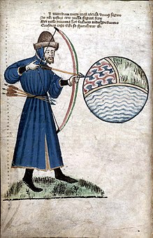
John Gower prepares to shoot the world, a sphere with compartments representing earth, air, and water (
Vox Clamantis, around 1400)
Dante's
Divine Comedy,
written in Italian in the early 14th century, portrays Earth as a
sphere, discussing implications such as the different stars visible in
the
southern hemisphere, the altered position of the
sun, and the various
timezones of the Earth. Also, the Elucidarium of
Honorius Augustodunensis (c. 1120), an important manual for the instruction of lesser clergy, which was translated into
Middle English,
Old French,
Middle High German,
Old Russian,
Middle Dutch,
Old Norse,
Icelandic,
Spanish, and several Italian dialects, explicitly refers to a spherical Earth. Likewise, the fact that
Bertold von Regensburg (mid-13th century) used the spherical Earth as a
sermonic
illustration shows that he could assume this knowledge among his
congregation. The sermon was held in the vernacular German, and thus was
not intended for a learned audience.
Portuguese exploration of
Africa and
Asia,
Columbus voyage to the
Americas (1492) and finally
Ferdinand Magellan's circumnavigation of the earth (1519–21) provided practical evidence of the global shape of the earth.
Islamic world
Islamic astronomy inherited the idea of a spherical earth from the
Greek astronomical tradition.
[39] The Islamic theoretical framework largely relied on the fundamental contributions of
Aristotle (
De caelo) and
Ptolemy (
Almagest), both of which worked with the premise that the earth was spherical and at the center of the universe (
geocentric model).
[39]
Early Islamic scholars recognized earth's sphericity,
[40] leading
Muslim mathematicians to develop
spherical trigonometry[41] in order to further mensuration and to calculate the distance and direction from any given point on the Earth to
Mecca. This determined the
Qibla, or Muslim direction of prayer.
- Al-Ma'mun
Around 830 AD, Caliph
Al-Ma'mun commissioned a group of
Muslim astronomers and
Muslim geographers to measure the distance from Tadmur (
Palmyra) to
al-Raqqah, in modern Syria. They found the cities to be separated by one degree of
latitude and the
meridian arc distance between them to be 66
2⁄3 miles and thus calculated the Earth's circumference to be 24,000 miles.
[42]
Another estimate given by his astronomers was 56
2⁄3
Arabic miles (111.8 km) per degree, which corresponds to a
circumference of 40,248 km, very close to the currently modern values of
111.3 km per degree and 40,068 km circumference, respectively.
[43]
- Al-Farghānī
Al-Farghānī
(Latinized as Alfraganus) was a Persian astronomer of the 9th century
involved in measuring the diameter of the Earth, and commissioned by
Al-Ma'mun. His estimate given above for a degree (56
2⁄3 Arabic miles) was much more accurate than the 60
2⁄3 Roman miles (89.7 km) given by Ptolemy.
Christopher Columbus
uncritically used Alfraganus's figure as if it were in Roman miles
instead of in Arabic miles, in order to prove a smaller size of the
Earth than that propounded by Ptolemy.
[44]
- Biruni
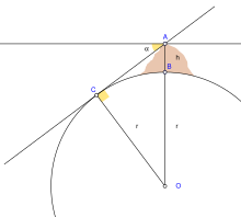
Biruni's Method for calculation of Earth's radius
Abu Rayhan Biruni (973-1048) used a new method to accurately compute the Earth's
circumference, by which he arrived at a value that was close to modern values for the Earth's circumference.
[45] His estimate of 6,339.9 km for the
Earth radius
was only 16.8 km less than the modern value of 6,356.7 km. In contrast
to his predecessors who measured the Earth's circumference by sighting
the Sun simultaneously from two different locations, Biruni developed a
new method of using
trigonometric calculations based on the angle between a
plain and
mountain
top which yielded more accurate measurements of the Earth's
circumference and made it possible for it to be measured by a single
person from a single location.
[46][47]
Biruni's method was intended to avoid "walking across hot, dusty
deserts" and the idea came to him when he was on top of a tall mountain
in India. From the top of the mountain, he sighted the angle to the
horizon which, along with the mountain's height (which he calculated
beforehand), allowed him to calculate the curvature of the Earth.
[48][49] He also made use of
algebra to formulate trigonometric equations and used the
astrolabe to measure angles.
[50]
John J. O'Connor and Edmund F. Robertson write in the
MacTutor History of Mathematics archive:
"Important contributions to
geodesy and
geography were also made by Biruni. He introduced techniques to measure the earth and distances on it using
triangulation. He found the
radius of the earth to be 6339.6 km, a value not obtained in the West until the 16th century. His
Masudic canon contains a table giving the coordinates of six hundred places, almost all of which he had direct knowledge."
[51]
Early Modern period
Circumnavigation of the globe
The
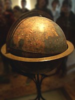
Erdapfel, the oldest surviving terrestrial globe (1492/93)
The first direct demonstration of Earth's sphericity came in the form
of the first circumnavigation in history, an expedition captained by
Portuguese explorer
Ferdinand Magellan.
[52] The expedition was financed by the Spanish Crown. On August 10, 1519, the five ships under Magellan's command departed from
Seville. They crossed the
Atlantic Ocean, passed through the
Strait of Magellan, crossed the Pacific, and arrived in
Cebu, where Magellan was killed by Philippine natives in a battle. His second in command, the Spaniard
Juan Sebastián Elcano, continued the expedition and, on September 6, 1522, arrived at Seville, completing the circumnavigation.
Charles I of Spain, in recognition of his feat, gave Elcano a
coat of arms with the motto
Primus circumdedisti me (in Latin, "You went around me first").
[53]
A circumnavigation alone does not prove that the earth is spherical.
It could be cylindric or irregularly globular or one of many other
shapes. Still, combined with trigonometric evidence of the form used by
Eratosthenes 1,700 years prior, the Magellan expedition removed any
reasonable doubt in educated circles in Europe.
Ming China
In the 17th century, the idea of a spherical earth, now considerably advanced by
Western Astronomy, ultimately spread to
Ming China, when
Jesuit missionaries,
who held high positions as astronomers at the imperial court,
successfully challenged the Chinese belief that the earth was flat and
square.
[54][55][56]
Summary of evidence for a spherical earth
These are given in an order which approximates how they were observed historically:
- When at sea it is possible to see high mountains or elevated lights
in the distance before lower lying ground and the masts of boats before
the hull. It is also possible to see further by climbing higher in the
ship, or, when on land, on high cliffs.
- The sun is lower in the sky as you travel north, but stars such as
Polaris, the north star, are higher in the sky. Other bright stars such
as Canopus, visible in Egypt, disappear from the sky.
- The earth throws a circular shadow on the moon during a lunar eclipse.
- The times reported for lunar eclipses (which are seen
simultaneously) are many hours later in the east (e.g. India) than in
the west (e.g. Europe). Local times are confirmed later by travel using chronometers and telegraphic communication.
- When you travel far south, to Ethiopia or India, the sun throws a
shadow south at certain times of the year. Even further (e.g. Argentina)
and the shadow is always in the south.
- It is possible to circumnavigate the world; that is, to travel around the world and return to where you started.
- Travelers who circumnavigate the earth observe the gain or loss of a day relative to those who did not. See also International Date Line.
- An artificial satellite can circle the earth continuously and even be geostationary.
- The earth appears as a disc on photographs taken from space, regardless of the vantage point.
Several of these arguments have alternative explanations by themselves. e.g. the shadow thrown by a lunar eclipse
could be caused by a disk-shaped earth. Similarly the north-south movement of stars in the sky with travel
could mean they are much closer to earth. However, the arguments strengthen each together.
Geodesy
Geodesy, also called
geodetics, is the scientific discipline that deals with the measurement and representation of the Earth, its
gravitational field and geodynamic phenomena (
polar motion, Earth
tides, and crustal motion) in three-dimensional time-varying space.
Geodesy is primarily concerned with positioning and the gravity field
and geometrical aspects of their temporal variations, although it can
also include the study of Earth's
magnetic field. Especially in the
German speaking world, geodesy is divided into
geomensuration ("Erdmessung" or "höhere Geodäsie"), which is concerned with measuring the Earth on a global scale, and
surveying ("Ingenieurgeodäsie"), which is concerned with measuring parts of the surface.
The Earth's shape can be thought of in at least two ways;
- as the shape of the geoid, the mean sea level of the world ocean; or
- as the shape of Earth's land surface as it rises above and falls below the sea.
As the science of
geodesy measured Earth more accurately, the shape of the geoid was first found not to be a perfect sphere but to approximate an
oblate spheroid, a specific type of
ellipsoid. More recent measurements have measured the geoid to unprecedented accuracy, revealing
mass concentrations beneath Earth's surface.


0 comments:
Post a Comment